
Sunday, June 24, 2012
Friday, June 22, 2012
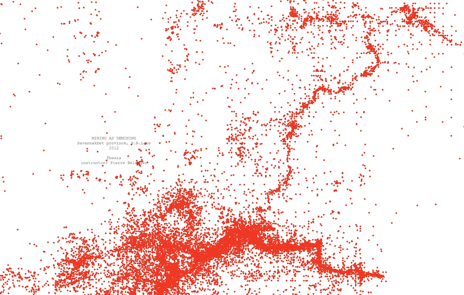


Wednesday, March 28, 2012
great thinking comes out of discussion
Charles Waldheim_
NUANCED APPROACH
John Davids_
…the 270 million bombs both "trampled" the land and then indeed prevented the land from further colonial exploitation afterward…
(*back to my ‘the art of touching the ground’/the bombs are protecting the land in an irony way)
…How much cleaning/mining you allow will be your critique of both the past abuses and the abuse inherent in raw, unmitigated colonial/capitalist exploitation
Brian Goldstein_
…making the gold companies into your "landscape architects"
(*the digging and reconstructing idea)
Don't necessarily take the Australians' presence as a given--work with it… (maybe) there is no one else who can do it and you must work around them, but your goal is to make their presence positive
Kelly Doran and Pierre Belanger_
Ground and aerial
Social culture value
More than REMEDY
Gold Buddha
Layers (Soil condition, water)
Grading the land
Gridding the land
other forces shaping the landscape (Weathering)
critic of the Infinite search of pattern
improve current logic / thinking
rethinking about waste
Diversifying the interrelation
Gold mining as Incubator
The lease outline
Taking advantage of the waste/ By product
Rethinking about the ‘bigness’
How you use the area that you can’t touch / Excluded land
post-midterm/post-war/post-mining
MID-TERM REVIEW
Monday, March 26th, 11:00am-6:30pm, Room 123
DISCUSSION
today, Wednesday, March 28th, 10:30am-12:30pm, Room 510
with Kelly Nelson Doran and Pierre Belanger
2pm - 3pm
with Kelly Nelson Doran and Pierre Belanger
2pm - 3pm
with Pro. Kongjian Yu
-need a few hours’ break now—
-then-
PENNY WHITE PRESENTATION
The Art of Touching the Ground
Friday, March 30th, 1:30pm-2:30pm, , Room 124
PRESENTATION
Mining as Demining
to BLA2551 class, Chulalongkorn University,Thailand
Saturday 10:00am -11:00am, March 24th
THESIS MEETING
With Pierre Belanger
Tuesday, April 3rd, 3:00pm


Wednesday, March 7, 2012


Tuesday, February 7, 2012


Friday, January 20, 2012
Update Penny White Trip Part III _ INFRA PICTURES
I finally got those films developed *one day* before the thesis kick-off meeting on the 19th, Jan, 2012.

MAG bomb clearance site, Xiang Khouang, Laos
Foreground: rice paddy field in dry season when farmers are not growing rice on site, but rather growing vegetables in the gardens near by. Yellow sticks in the field indicate where the MAG team has found the UXO, which will be destroyed at 3 pm everyday.
Background: spots of vegetation over the hill indicate where the bomb craters are - four decades after the bombing ended, the bomb craters have changed from symbols of death into ones of life - most of them are now covered with trees or shrubs. White patches over the hill indicate the clearings local people made to trap swallows, which is a special food Xieng Khouang is famous for.

MAG bomb clearance site, Xiang Khouang, Laos
Her name is Vienglada, Deputy Team Leader of UCT13, MAG.

MAG bomb clearance site, Xiang Khouang, Laos
The clearance site has been used as rice paddy field for more than 30 years. The owners of the land grow rice on site in raining season. They know there are UXO, and they found scrap metal on site all the time, but they have no choice other than keep farming.
The clearance site is around 4 hectar. The operation started on 28/12/2011. I got there on the 5th of Jan, by then, the team found and destroyed 79 BLU UXO. One day before I got there, they found a 500 lb big bomb.
The clearance site is around 4 hectar. The operation started on 28/12/2011. I got there on the 5th of Jan, by then, the team found and destroyed 79 BLU UXO. One day before I got there, they found a 500 lb big bomb.

Small trees in a big bomb crater, Xieng Khouang, Laos

Trees growing inside the bomb craters over the hill, Xieng Khouang, Laos

Vegetations growing inside a bomb crater, Xieng Khouang, Laos

Trees growing inside the bomb craters over the hill, Xieng Khouang, Laos

View from the air, Xieng Khouang, Laos

View from the air, Xieng Khouang, Laos

Mekong River in dry season, Vientiane, Laos
With trees growing on the other side of the Mekong bank (Thailand) in the background

View from the air, near Vientiane, Laos

View from the air, near Vientiane, Laos

View from the air, near Xieng Khouang, Laos

Roads in the mountain leading to the construction site of Nam Ngiep II Dam project, Xieng Khouang, Laos
10.9km of roads are newly created as part of the infrastructure setting up for the Nam Ngiep II Dam

Nam Ngiep River on the Nam Ngiep II Dam construction site, Xieng Khouang, Laos

Nam Ngiep II Dam construction site, Xieng Khouang, Laos
Trees are being cleared on the slope

Nam Ngiep II Dam construction site, Xieng Khouang, Laos
Nam Ngiep river is shown in blue in the center of the image

Roads in the mountain leading to the construction site of Nam Ngiep II Dam project, Xieng Khouang, Laos
Subscribe to:
Posts (Atom)